

This is my own narrative of my journey to the summit of Kebnekaise, the highest mountain in Sweden. This is a follow-up to the press story about it that I posted yesterday. Here you’ll find more background on why and how I did it.
Where it all started… an unexpected journey
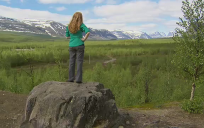
Last year during filming of Allt för Sverige, I found myself standing on a hill in a valley at the edge of the mountains in the far north of Sweden. In the middle of the emotional rollercoaster that the adventure turned out to be, I had a moment of inspiration. I stood there singing to myself as the clouds cleared away, revealing pristine alpine meadows and glaciers and cliffs. The wind swept over me, and I felt a sheer contentment and the desire to go to those mountains. To walk through them and explore them with my own two feet.
As I left that hill I came across a poem engraved in a stone, by a bench looking out at the mountains. It was in Swedish so I didn’t know what it meant, but it struck me as a sacred, inspiring place.

When I came down the hill to rejoin my Allt för Sverige friends I passed a trail with a sign that said “Kebnekaise 19 km.” I knew Kebnekaise was the tallest mountain in Sweden. To unexpectedly see that it was only 19 km away from where I stood… it felt so close I could almost taste it, and I wanted to go grab my backpack right then and there and start walking. But I had to file that image away in my memory and just promise myself I would return someday.
I wanted to climb Kebnekaise, just to find out whether I could.
After I returned home to the US, I was looking through my photos and found the pictures of the mountain, and the poem in the rock. The translation was:
Let the mountain wind caress your cheek.
Let the rain wash your face.
Let the mountain wind blow your heart clean.
Come and see the playful light.
And the brightly lit sky.
Come play with the mountain wind.
Don’t be afraid. Go wandering far.
Don’t be afraid. The wind will point you in the right direction.
Let the mountain wind caress your cheek.
Come!
— Paulus Utsi
(Thanks to my facebook fan Björn Winberg for the translation!)
This poem in a language that I didn’t even understand had captured the powerful truth that I felt on that hill – the mountains calling me onward. Let go of fear. Trust. Go play in the mountains. I decided to go back, as soon as I could.
But first, I was going to need to know how to climb a mountain, and train hard to be able to make the journey.
Learning to Climb a Mountain
Having been an avid hiker who dabbled in rock climbing, had toyed with the idea of joining my local Mountaineers club for several years, and the goal of Kebnekaise gave me the push I needed to finally do it. I enrolled in an “Alpine Scrambling & Winter Travel” course – scrambling is sort of halfway between hiking and full-on roped climbing – it requires off-trail navigation skills and the ability to safely negotiate steeper terrain of rock or snow. A vast number of peaks in Washington state can be reached with scramble routes, and so, it turns out, can Kebnekaise in Sweden.
During the course we learned the basics of mountaineering that everybody needs to know, like the ten essential systems of wilderness travel, the importance of the right clothing (the right boots are worth their weight in gold), how to make a simple hasty harness from webbing and knots, snow travel skills and ice axe arrest, and conditioning for endurance. I completed a wilderness navigation/orienteering class, practiced following a bearing through steep and dense rainforest terrain. Field trips to the mountains gave us opportunities to practice our skills, and during those trips I got explore the mountains in my own backyard, plus to learn how my CF impacts me out in the real-world wilderness.
Thanks to the wonders of the Internet I was able to do much of the planning for the trip online. Four of us would be making the attempt together: me, my father (quite fit at age 67 – an avid outdoorsman who has summited Mt. Rainier in Washington State), my Swedish relative Anne (a personal trainer who I met during Allt for Sverige), and her “man.”
The Swedish explorer/philanthropist Johan Ernst Nilsson also offered to join our team, though for logistical reasons he wasn’t able to make it. We did get a chance to meet up in Stockholm before I headed north to talk through the route. He was very encouraging, as is his way, and his experience from his multiple trips up Kebnekaise was very helpful with filling in the gaps I hadn’t been able to learn about online. His parting words were, “I’d wish you luck, but I don’t think you need it.”
That is a confidence booster, right there!
A photo posted by Katie Malik (@katie.malik) on
Day 1: Nikkaluokta to Kebnekaise
It was a late spring in Sweden this year, and a cool and cloudy summer. We had set the date for our trip up Kebnekaise back in February, knowing we had a limited window during our trip and crossing our fingers that the weather would cooperate.
We hit the jackpot. The weather for the 19 kilometer hike from where I stood the year before on the hill at Nikkaluokta to the Kebnekaise fjallstation was ideal. Comfortably cool enough for hiking, with high clouds that didn’t obstruct the views and took the harshness off the sun.
The trail is quite rocky, so even though the trail is well worn I found myself placing each step carefully. Still, the first 5 kilometers between the trailhead and the passenger ferry landing went by quickly. It is possible to walk the whole 19 kilometers, but we decided to take the ferry to save our energy for the summit the next day, and for the change of pace that it would give us along the way.
Also, as much as Kebnekaise would be a challenge for me, this hike to the fjallstation was a goal that my mom had set for herself. She trained up hard to be able to do it with us, and it was wonderful to have her there, right along side me and joining me when I felt like singing along the way. So I was happy that the ferry would give her a chance to rest and give her the boost she needed to make it the rest of the way.
There was a certain peak that I’d seen at a distance the previous summer, with a sheer drop down toward the river. I remember wanting to see what was on the other side of it. I watched as it came closer, and then as we rounded the corner there was a whole new vista beckoning us onward. It motivated us to keep going, seeing the changing views through the day. Much of the trail comprised low and long wood bridges – a reminder of how wet the landscape can become when snow melt turns it into a kilometers-long collection of shallow streams.
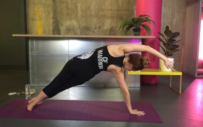
I remember one stop along the way, where a big boulder lay in a clearing with a view of the mountains all around. It will come as no surprise to anyone to knows me that I went to stand on top of it and sing, take my pack off and do a bit of stretching. My Dad even joined in for some yoga on the rocks.

Just a normal day, doing yoga with dad on a rock in the arctic.
The last few kilometers felt really long. We could see the fjallstation from a distance but it didn’t seem to get any closer. My pack, which weighed in around 30 pounds since I had to carry all my medications, was starting to feel quite heavy and I was ready to call it a day. But finally we made it, with a couple of hours until dinner and enough time to get situated in our room. We asked around and everyone said conditions were near perfect. There were still snow bridges over the big river crossings and the conditions up top were ideal, we wouldn’t even need our crampons.
I highly recommend dinner at the lodge restaurant. World class. With full bellies we turned in for the night, knowing we’d have to get up for an early start the next day.
Day 2: The Summit of Kebnekaise
We chose the longer self-guided western route ( Västra Leden) to the summit instead of the shorter but more advanced eastern route. We set out at 8:00 am with the goal of making it up to the summit and back in 12 hours, so we could be back in time for our dinner reservations at the lodge. But it would be a challenge. There is another mountain before Kebnekaise that would have to be climbed, and then there’s a descent down a valley before you climb up Kebnekaise.

The head of the western trail up Kebnekaise
I told the team that morning that I/we needed to keep good account of our bodies and if we could only reach that first summit and not continue to Kebnekaise, it would still be a victory. The whole point is to get into and enjoy the mountains, not just to reach the summit. So in order of priority, our goals were:
- Be safe
- Enjoy where you are
- Reach the the halfway point, the first summit (Vierramvare – 1711 m)
- Make it to the summit of Kebnekaise (2113 m)
- Be back in time for dinner
The trail falls into some pretty distinct sections. The first part was just a long walk along the valley floor, with more of the same rocky/sandy ground that we’d walked through the day before. We passed many campsites for the first kilometer or so, and marveled at the views as we walked closer to the base of the mountains. We crossed several small streams, and my mountaineering boots got their first taste of Swedish water. (My feet stayed good and dry – thanks to that lesson about having good boots!) We reached the Västra Leden sign, and also saw where the trail forked and the Kungsleden trail branched off to the left, between two huge peaks. We stayed to the right and began to gain our first bit of elevation as we turned in toward the mountains surrounding Kebnekaise.

End of part I. Where the trail turns in toward the mountains. [Click to enlarge]

One of the interesting alpine plants
I began to use my rest-step breathing as the terrain steepened. Inhale and place one foot uphill, exhale and shift the weight to the uphill foot. Inhale place the other foot. Exhale step. It’s a slow but steady pace – I can move about 1 mile per hour climbing up steep terrain this way, and I only need to stop for a food break about once an hour. I did some mental math and knew that making it for dinner was an ambitious goal. I was thankful I’d brought plenty of food, and been able to unload my bag in our room at the lodge, only leaving about 10 pounds of weight for my essentials (e.g. water, food, emergency shelter, crampons just in case…).
Partway up this valley was the biggest river crossing, where water melts down from the three peaks. The snow bridge was still intact, to our delight, but snow bridges are ever-changing and must always be crossed cautiously, especially on hot days. One at a time, we headed across taking steps gingerly through the snow.
After the snow bridge crossing was when we really started climbing in earnest. We had the first patch of snow to cross as we climbed. There were already many tracks in the snow along the trail, but the snow was quite soft and your feet would slide if you didn’t use techniques to save energy. I showed my cousin how to kick in steps to the snow as you walked, so that you have a sturdy place to step and each person in a team makes it a little easier for the person behind them.
As we moved onto the slopes of Vierranvárri we moved into the sun, and the snow disappeared. It was so warm that I was down to my tank top for a few hours. An entire mountain of scree field – placing each step carefully and making sure it could bear the weight before moving onto it made it slow going, but I was rest-stepping in sync with my breathing anyway so there was no way to rush through it. We kept getting passed by group after group, and I’d say “slow and steady…” We began to have enough elevation to see glimpses of the surrounding mountains, and the vistas would change as the trail switched back and forth up the hill.

The view back to the valley we walked through the day before in the distance. The sheer cliff rising up the left side of the river is the landmark I saw a year before, when I decided I wanted to climb this trail. [Click to embiggen]
We decided to sit and enjoy our lunch, and see how the food recharged me. The view was spectacular, with the valley to the south and the dramatic mountains to the north and west. I looked across to the broad slope of Kebnekaise, the descent down the valley that we would have to make and it looked so huge and impossible. But then I picked out the figures of the people climbing up the trail on the other side, and noticed that they were not really all that small. It was closer than it looked. My energy level was recharged as the food hit my system, and I said, “OK, who wants to go for the top?”
Dinner be damned. I wanted that mountain.
The descent down into the valley was a fun break from all the climbing. There was a patch of snow on the hill so there was some slipping and sliding involved, and it was a refreshing change from all the rocks. But it was over quickly and then it was time to downshift for the last push up the big mountain. Uphill the rest of the way.
Kebnekaise is a shy mountain. Though it’s the highest in Sweden, you can’t see the summit anywhere along the western trail until you are almost there. The mountain itself, its rocky soul, is very round and flat. You can’t see the top and you can’t even tell how much farther you have left to go because the mountain blocks you from itself. All you have to go on is the views around you. When we looked over our shoulders and found ourselves back at the same elevation we had been for lunch, it felt like a small victory. We saw more and more of the mountains unfolding to the northwest and stretching over into Norway. Anne and Anders went ahead and so my Dad and I walked just the two of us for a while. 67-year-old father and 35-year-old daughter (with a chronic disease) were a great pair, moving at a pace that fit naturally to both of us. And we stopped to take each others’ pictures with the mountains at our back.

View from western slope of Kebnekaise. [Click to embiggenate.]
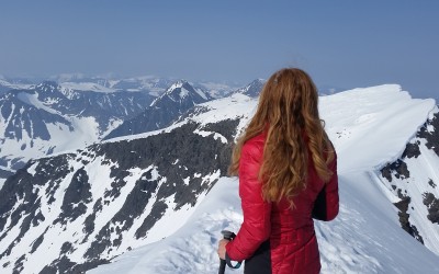
A few minutes later, as I took what felt like just another step like the others, I finally saw it. A tiny, white spike glinting over the horizon. With each step more of it was revealed, and moments later I saw the full peak of the “sydtoppen” summit glacier.

The summit… at last!
Sheer down three sides, just a little tiny point that you could climb up and stand on the very top. The highest point in Sweden is quite literally a “point.” They say that with all the glacial melt in the arctic, barring significant improvement it will only be the highest point for a few more years, when the rocky summit at “norrtoppen” (the northern summit) will be higher. So I’m glad that I got to see it when I did.
We left our bags down at the edge of the rocks before we stepped onto the glacier and made our final push up the steep slope. Kicking in steps, breathing, rising quickly to the top. And then… there I was.
Looking out across the view, every peak lower than where I stood. Sheer cliffs. Glaciers. Blue rivers of water running together under the snow. I can close my eyes and picture it in my mind’s eye. The flat space at the top is no larger than a card table. The impassable sheer cliffs on three sides make some people afraid and they leave after just a moment. But as ever-present the danger was, I felt safe. I was comfortable there.

Moment of disbelief at the Kebnekaise summit, the highest point in Sweden. July 2015.
One long last look, and I turned around to descend.
We reached the summit at about 16:00. It had taken us eight hours to reach the top, so we were pretty sure we wouldn’t make it back in time for dinner a short four hours from now. We knew my mom would worry if we were late getting back, so Anne and her man went ahead down at their faster pace. That way they could tell her we made it and were OK, just needed a bit more time to get back.
The road down felt so long, especially the last few kilometers when we were down in the valley. We made it back at about 10:00 pm, ate a hurried cold dinner that they had saved for us, and collapsed into bed.
All told it took a year of planning, six months of training, and a team of many to get there, but I did it. If I can do this, I can do anything.
Objective, achieved.

Katie Malik (age 35) and her father David Robertson (age 67) at the summit of Kebnekaise, the highest point in Sweden. July 2015.

Well done on your trip and a really enjoyable read!
Hope to make it there myself soon 🙂